
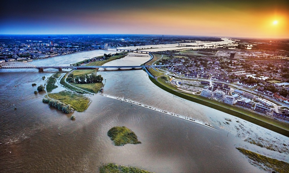
Room for the Waal River in the Netherlands. © Courtesy of Royal HaskoningDHV
Allowing rivers to move rather than engineering them into artificial channels is a nature-friendly way to reduce flooding. By Tom Kay
Last June, an incredible 551 mm of rain fell on the Canterbury foothills over three days. The waters of the Hakatere Ashburton River rapidly rose to a peak of 1794 m³/s – the highest flow gauged since records began in 1956. The stopbanks held in Ashburton, but in the nearby countryside a terrifying volume of water rose up and out over the top.
Three hundred residents had to be evacuated for their own safety, and the flooding cut off small towns, damaged homes, closed roads, destroyed bridges, and inundated farms. Insurance claims topped $46m, and the cost of flood recovery is likely to total nearly $20m across the region, according to Environment Canterbury.
Forest & Bird magazine
A version of this story was first published in the Winter 2022 issue of Forest & Bird magazine.

It was one of at least eight serious flooding events over the past five years that have caused huge damage and stress to communities in Tairāwhiti Gisborne, Central Hawke’s Bay, Westport, Fox River, Franz Joseph, and Canterbury. In 2017, the entire town of Edgecumbe, in the Bay of Plenty, was forced to evacuate.
As climate change continues, we’re going to experience more frequent and intense rain events across Aotearoa. These will bring higher river flows and more flooding than ever before.
Historically, we’ve tried to protect our communities from flooding by “engineering” our rivers into massive drains. We’ve used diggers and bulldozers to artificially straighten, deepen, and line them with rock groynes and stopbanks in the hope this will stabilise them.
The aim is to keep floodwaters away from communities and drain them out to sea as quickly as possible. While this might work for smaller floods, in other cases, including those mentioned above, these hard-engineered solutions are actually increasing the risk of flooding to our communities.
When the floodwaters start to rise, these embankments increase the depth of water in the river, and when it eventually overtops or breaches the banks the floodwaters are higher and have much more energy than they would otherwise. The consequences can be catastrophic and fatal.
Traditional hard-engineered solutions provide a false sense of security. It’s given us the idea that it’s safe to build homes and communities right up to the edges of rivers.
The works also destroy important habitat for native fish, birds, and insects. Wetlands disappear, and rivers are disconnected from their floodplains and the aquifers beneath them.
These unintended consequences degrade natural “wild” rivers, ruin traditional kai gathering spots, and negatively impact our cultural, social, and economic wellbeing.
The ongoing cost of maintaining our country’s flood protection infrastructure and cleaning up after floods is (and continues to be) enormous.

The natural flow of the Hutt River has been constrained by urban development over the past 80 years. Still from video. Credit Wellington Regional Council
But there is another way – a nature- and climate-friendly way – that could make our communities more resilient. Internationally, there has been a move away from traditional flood-mitigation techniques. In some countries, most notably in the Netherlands, communities are making room for rivers to give them space to flood safely.
Dutch cities and towns experienced unprecedented floods during the 1990s that overwhelmed local flood protection infrastructure and triggered the evacuation of hundreds of thousands of people and a million livestock.
Government officials decided to do something different. In 2007, they started a nature-based Room for the River programme to restore natural flood plains in strategic places, allowing space for rivers to flood safely.
The €2.3 billion programme, which has been carried out at more than 30 locations across the Netherlands and is expected to finish this year, involves tailor-made solutions for each river.
Measures include lowering and widening floodplains, restricting development on floodplains, strengthening and relocating stopbanks, reducing groyne heights, and removing obstacles.
Essentially, landscapes are given back their capacity to accommodate excess water during floods. A key part of the programme is improving the amenity of the surrounding river banks, benefiting nature and the public.
A study of two Dutch rivers in the programme, the Rhine and the Meuse, found that widening their floodplains to reduce river levels by 30cm during floods reduced the probability of dyke failure by two to five times. Lowering river levels by 50cm cut the risk of failure by more than 10 times.
It’s a nature-based solution that has placed the Netherlands well ahead of other nations in adapting to the impacts of climate change.
Making room for rivers has improved their residents’ quality of life, allowed more space for wildlife and recreation reserves, promoted housing developments in safer spaces, and better protected heritage villages, sand dunes, and beaches – all of which are important to local tourism.
It has also been more costeffective than constantly repairing flood protection infrastructure and rebuilding roads, bridges, and towns after large floods.
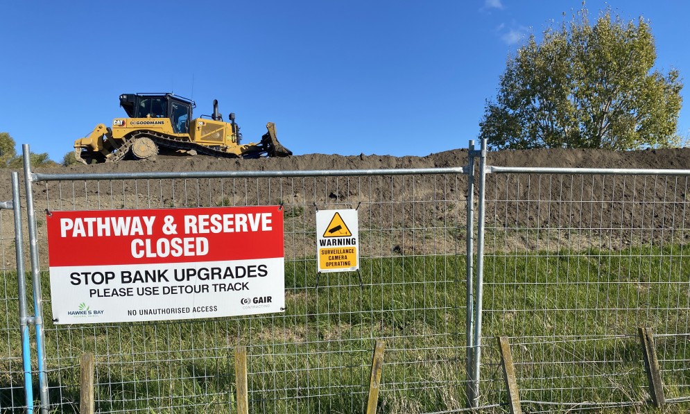
Upgrading flood protection infrastructure, Tūtaekuri River, Hawke’s Bay. Credit Caroline Wood.
International engineering consultancy firm Royal HaskoningDHV was involved in the most challenging Room for the River projects in the Netherlands. Its global director of climate resilience, George Peters, said: “We are proud to have been part of this strategic programme which breaks with the traditional Dutch reliance on dike reinforcement in flood risk management.
“Instead, we employed nature-based solutions that increased the rivers’ water-carrying capacity by opening up more room for the water to naturally flow. As a result, residents are safer, communities are more resilient, and the whole area is more attractive for recreation and tourism opportunities.”
Here in Aotearoa, we’ve been slow to adopt the “room for rivers” approach. The government and most councils are still spending millions of dollars raising stopbanks and engineering riverbeds.
However, things might be starting to change, with some New Zealand scientists questioning the current approach.
The New Zealand Rivers Group, which is made up of key government and council experts and decision-makers, has made Making Room for Rivers the theme for its entire 2022 conference.
The concept is also making its way, albeit slowly, into the lexicon of a few councils, including Horizons, Tasman, and Wellington.
For example, under its Riverlink project, Wellington Regional Council is planning to lower and widen Te Awa Kairangi Hutt River, giving it more room to flow, allowing a higher volume of water to pass down the river during floods, and creating more fish habitat.
Forest & Bird believes it’s time to seriously consider trialling this new Room for the River approach to protect our communities from the impacts of climate change. It’s a win-win strategy that will increase the wellbeing of our rivers, local communities, and the wildlife that depends on these special freshwater habitats.
Tom Kay is Forest & Bird's Freshwater Advocate.